Nauru Profile
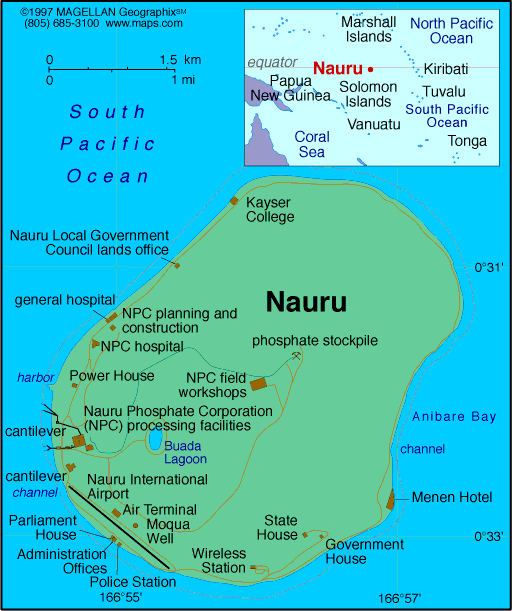
Nauru is a small island nation located in the central Pacific Ocean, just south of the equator. A map of Nauru reveals a single oval-shaped island surrounded by a coral reef, with no natural harbor. Despite its small size, Nauru has a unique geography, a complex colonial history, and a distinct identity as one of the least-visited and least-known countries in the world.
Covering just 21 square kilometers, Nauru is the third smallest country by area globally and the second smallest by population. The interior is dominated by a phosphate plateau, while a narrow coastal strip is home to the island's settlements and infrastructure.
History of Nauru
Originally settled by Micronesian and Polynesian peoples, Nauru was a self-sufficient society before Western contact. The island was annexed by Germany in 1888, followed by Australian, British, and New Zealand administration after World War I. During World War II, it was occupied by Japanese forces.
After the war, Nauru came under UN trusteeship before gaining independence in 1968. The island experienced a boom due to phosphate mining, but depletion of resources brought economic challenges. Today, Nauru remains heavily reliant on aid and offshore services, with efforts to diversify the economy and restore mined land.
Geography of Nauru
The geography of Nauru is defined by its isolation, limited space, and resource-based terrain. It is a raised coral atoll with a ring of fertile coastal land surrounding a central plateau known as Topside.
-
Topside Plateau: Formerly rich in phosphate, now largely mined out and barren
-
Coastal Belt: Contains the island’s main settlements, roads, and airport
-
Buada Lagoon: A small freshwater lagoon surrounded by vegetation
-
Coral Reef: Surrounds the island, making maritime access difficult
Nauru has no rivers and limited natural freshwater, relying on rainwater collection and desalination. Its tropical climate brings consistent heat and humidity year-round.
Major Districts
Nauru has no official cities. Instead, it is divided into 14 districts:
-
Aiwo
-
Anabar
-
Anetan
-
Anibare
-
Baiti
-
Boe
-
Buada
-
Denigomodu
-
Ewa
-
Ijuw
-
Meneng
-
Nibok
-
Uaboe
-
Yaren (de facto capital and seat of government)
Facts & Figures About Nauru
-
Population: Approximately 10,000
-
Capital: No official capital; Yaren acts as the administrative center
-
Official Languages: Nauruan, English
-
Currency: Australian dollar (AUD)
-
Main Industries: Phosphate mining, public services, offshore banking
-
Climate: Tropical with monsoon season from November to February
-
Independence: 1968 (from UN trusteeship)
People also ask…
Where is Nauru located on the map?
Nauru is in the central Pacific Ocean, northeast of Australia and just south of the equator, part of Micronesia.
What is Nauru best known for?
Nauru is known for its phosphate mining history, small population, and status as one of the least-visited countries in the world.
Does Nauru have a capital city?
Nauru does not have an official capital. However, Yaren District functions as the seat of government.
Is Nauru safe to visit?
Yes, Nauru is generally safe. However, its remote location and limited tourism infrastructure make travel logistics challenging.
|
|
 |


