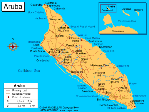
Aruba Profile
Nestled in the southern Caribbean, just north of Venezuela, Aruba may be a small island, but it packs a big punch with its stunning beaches, vibrant culture, and unique landscapes. From the colorful streets of its capital, Oranjestad, to the quiet charm of its coastal towns and rugged inland scenery, Aruba offers a perfect mix of Dutch Caribbean heritage and modern island energy.
Home to around 120,000 people, the island is famous for its powdery white sands, turquoise waters, and the iconic windswept divi-divi trees. Its compact size makes it easy to explore, from snorkeling over vibrant coral reefs and wandering through desert-like terrains to discovering lively markets and historic Dutch architecture.
With a thriving tourism scene, welcoming communities, and a rich cultural calendar, Aruba proves that even a small island can leave a big impression.
History of Atuba
Aruba is a neighborhood in the city of Curitiba, Paraná, Brazil, lying along the border with the neighboring municipality of Colombo. The area takes its name from the Rio Atuba, a river that runs through the region. The name itself comes from the Tupi‑Guarani language, reflecting the Indigenous linguistic roots of many place names in southern Brazil.
The early history of Atuba is closely tied to the colonial expansion and settlement of the Curitiba region. In the 17th century, Portuguese prospectors and pioneers explored this area as part of their incursions into the interior of southern Brazil, looking for minerals and other resources. These early settlements and exploratory camps laid the groundwork for later permanent communities.
Historical records from the late 18th and mid-19th centuries show that Atuba was already recognized as a notable area. In 1780, authorities documented a request to clear and maintain the Atuba River, and by 1853, the area appeared on official maps as part of the expanding settlement that would eventually grow into Curitiba.
Over time, what began as scattered pioneering settlements evolved into an established urban neighborhood as Curitiba expanded throughout the 20th century. Today, Atuba is part of the broader metropolitan area of Curitiba, with both residential and recreational areas, including parks that help preserve parts of the river valley and natural landscape.
Geography of Aruba
Aruba is a small island in the southern Caribbean Sea, about 29 kilometers north of Venezuela. It is the westernmost of the ABC islands, which include Aruba, Bonaire, and Curaçao, and is part of the Kingdom of the Netherlands. The island does not share land borders, but its closest neighbors are Venezuela to the south and the other ABC islands to the east.
The island is relatively flat and dry compared to many Caribbean islands, giving it a desert-like feel in some areas. Aruba stretches about 32 kilometers long and 10 kilometers wide, covering roughly 180 square kilometers. Its coastline is known for white-sand beaches and clear turquoise waters, especially along the western and southern shores, which are protected from strong waves and currents.
Inland, the terrain has low hills, limestone formations, and dry plains. The highest point is Mount Jamanota, rising 188 meters above sea level. About a fifth of the island is part of Arikok National Park, which preserves the rugged landscapes, native plants and animals, and historic caves with Indigenous rock art.
Aruba has a tropical semi-arid climate with constant trade winds, plenty of sunshine, and little rainfall. This dry climate supports cacti and other desert plants, and being outside the hurricane belt makes Aruba one of the Caribbean’s safest islands from storms.
Major Cities
-
San Nicolaas
-
Palm Beach
-
Noord
-
Santa Cruz
-
Paradera
-
Savaneta
-
Malmok
-
Pos Chiquito
-
Mangel Halto
Interesting Facts About Aruba
-
Sunny and friendly: Aruba is nicknamed “One Happy Island” because of its warm climate and welcoming people.
-
Outside hurricane belt: The island rarely experiences hurricanes, making it a safe Caribbean destination year-round.
-
Languages: Dutch and Papiamento are official, but English and Spanish are widely spoken.
-
Protected nature: Arikok National Park covers about 20% of the island and preserves wildlife, rugged terrain, and Indigenous rock art.
-
Iconic trees: The divi-divi tree, bent by constant trade winds, is a famous symbol of Aruba.
-
Tourism-driven economy: Aruba’s economy relies heavily on tourism, along with oil refining and international trade.
-
World-class beaches: Aruba is famous for its white-sand beaches, including Eagle Beach and Palm Beach, often ranked among the best in the world.
People also ask…
What is the traditional cuisine of Aruba?
Aruban cuisine is a flavorful mix of Caribbean, Dutch, and Latin influences. Popular dishes include keshi yena (a baked cheese stuffed with meat and vegetables), fresh seafood like lionfish and grouper, and pastechi, a savory pastry filled with cheese, meat, or fish. Local fruits like papaya, mango, and guava are also commonly used in desserts and drinks.
What languages are spoken in Aruba?
Aruba has four main languages. The official languages are Dutch and Papiamento, a creole language unique to the island. English and Spanish are also widely spoken, especially in tourism, making it easy for visitors to communicate.
What are the most popular tourist attractions in Aruba?
Aruba is famous for its stunning beaches like Eagle Beach and Palm Beach, as well as Arikok National Park, which offers hiking trails, caves, and wildlife. Other highlights include Oranjestad for shopping and colorful architecture, the California Lighthouse, and various water activities such as snorkeling, diving, and windsurfing.
|
|
 |


