Marshall Islands Profile
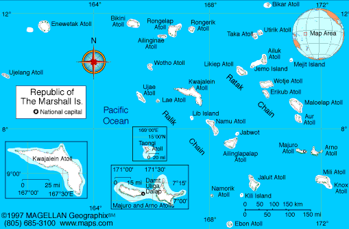
The Marshall Islands is a Pacific island nation located in Micronesia, positioned between Hawaii and the Philippines. A map of the Marshall Islands shows a vast ocean territory made up of 29 coral atolls and 5 single islands, spread across more than 1 million square kilometers of ocean. Despite this wide maritime area, the total land area is extremely small.
The country is known for its low-lying atolls, turquoise lagoons, and strategic location in the central Pacific. The capital, Majuro, serves as the political and economic center, while Ebeye is one of the most densely populated islands in the Pacific.
History of the Marshall Islands
The Marshall Islands were originally settled by Micronesian peoples who developed advanced navigation skills and strong maritime traditions. European contact began in the 16th century, followed by German control in the late 1800s. After World War I, the islands came under Japanese administration.
During World War II, the islands were heavily affected by fighting between Japanese and U.S. forces. After the war, the United States administered the Marshall Islands as part of the Trust Territory of the Pacific Islands. Between 1946 and 1958, the U.S. conducted nuclear testing at Bikini and Enewetak Atolls.
The Marshall Islands became a self-governing nation in free association with the United States in 1986. This agreement allows the islands to manage internal affairs while the U.S. provides defense and economic support.
Geography of the Marshall Islands
The Marshall Islands consist entirely of coral atolls and low islands, most rising only a few meters above sea level. The country is divided into two main island chains:
-
Ratak Chain: Eastern group of atolls, including Majuro
-
Ralik Chain: Western group, including Kwajalein and Bikini
The islands have a tropical climate with warm temperatures year-round and a wet season from May through November. There are no rivers or mountains, and freshwater resources are limited, making the islands vulnerable to drought and rising sea levels.
Large lagoons support fishing, coral reefs, and marine biodiversity, which are central to local livelihoods and culture.
Major Atolls and Population Centers
-
Majuro Atoll: Capital and main administrative center
-
Ebeye: Densely populated island on Kwajalein Atoll
-
Kwajalein Atoll: Site of a major U.S. military testing range
-
Jaluit Atoll: Historic administrative center during colonial periods
-
Bikini Atoll: Known for nuclear testing history
-
Enewetak Atoll: Former nuclear test site with ongoing monitoring
Facts & Figures About the Marshall Islands
-
Land Area: About 181 square kilometers
-
Population: Around 42,000
-
Capital: Majuro
-
Official Languages: Marshallese and English
-
Currency: United States dollar (USD)
-
Government: Republic in free association with the United States
-
Main Industries: Fishing, government services, aid-supported programs
-
Climate: Tropical maritime
-
Elevation: Average elevation less than 2 meters above sea level
People also ask
Where are the Marshall Islands located?
The Marshall Islands are located in the central Pacific Ocean, northeast of Papua New Guinea and east of the Philippines, within the Micronesia region.
What are the Marshall Islands known for?
They are known for coral atolls, World War II history, nuclear testing sites, and their vulnerability to climate change and rising sea levels.
Are the Marshall Islands independent?
Yes. The Marshall Islands is an independent country in free association with the United States, which provides defense and economic assistance.
What language is spoken in the Marshall Islands?
Marshallese and English are the official languages. Marshallese is widely spoken in daily life.
|
|
 |


