South Carolina Profile
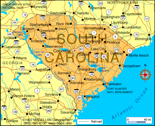
South Carolina is located in the southeastern United States, bordered by North Carolina, Georgia, and the Atlantic Ocean. A map of South Carolina shows a state divided into distinct geographic regions, ranging from coastal plains and barrier islands to rolling hills and upland plateaus. Its location along the Atlantic coast has played a major role in its history, economy, and culture.
Known for its historic cities, beaches, and strong regional identity, South Carolina blends colonial heritage with modern growth. Columbia is the capital, while Charleston is one of the most historically significant cities in the country.
History of South Carolina
South Carolina was originally inhabited by Native American tribes including the Catawba, Cherokee, and Yamasee. English settlers established Charles Town in 1670, and the colony became one of the wealthiest in British North America due to rice and indigo plantations.
South Carolina was the first state to secede from the Union in 1860, playing a central role in the Civil War. After Reconstruction, the state experienced economic and social changes through the 20th century. Today, South Carolina continues to grow through manufacturing, tourism, and port activity while preserving its historical legacy.
Geography of South Carolina
South Carolina covers approximately 82,930 square kilometers and is divided into three main geographic regions:
-
Coastal Plain: Includes beaches, marshes, and barrier islands along the Atlantic
-
Piedmont: Rolling hills and urban centers in the north central region
-
Blue Ridge Mountains: Small mountainous area in the northwest
The state is crossed by several major rivers, including the Savannah, Congaree, and Pee Dee. South Carolina has a humid subtropical climate with hot summers, mild winters, and occasional hurricanes affecting coastal areas.
Major Cities
-
Columbia – Capital city and government center
-
Charleston – Historic coastal city and major port
-
Greenville – Economic and cultural hub of the Upstate
-
Myrtle Beach – Popular coastal resort city
-
Spartanburg – Manufacturing and logistics center
-
Rock Hill – Growing city near the North Carolina border
Facts & Figures About South Carolina
-
Area: Approximately 82,930 square kilometers
-
Population: Around 5.3 million
-
Capital: Columbia
-
Largest City: Charleston (by population within city limits)
-
Statehood: 1788 (8th state)
-
Nickname: The Palmetto State
-
Major Industries: Manufacturing, tourism, agriculture, logistics
-
Climate: Humid subtropical
-
Coastline: Along the Atlantic Ocean
People also ask
Where is South Carolina located?
South Carolina is located in the southeastern United States, bordered by North Carolina, Georgia, and the Atlantic Ocean.
What is South Carolina known for?
South Carolina is known for its historic cities, beaches, Lowcountry culture, and role in early American history.
Does South Carolina have mountains?
Yes. The northwestern corner of the state includes part of the Blue Ridge Mountains.
What is the capital of South Carolina?
The capital of South Carolina is Columbia.
|
|
 |


