Missouri Profile
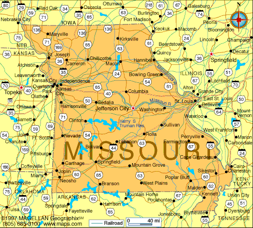
Missouri is a state located in the central United States, bordered by eight states including Illinois, Kansas, Iowa, and Arkansas. A map of Missouri shows a geographically diverse state that serves as a crossroads between the Midwest and the South. Its central location has played a major role in American expansion, trade, and transportation.
The state is defined by major rivers, rolling hills, plains, and forested highlands. Jefferson City is the capital, while Kansas City and St. Louis are the largest metropolitan areas and economic centers.
History of Missouri
Missouri was originally inhabited by Native American tribes such as the Missouria, Osage, and Illini. European exploration began with French traders in the 17th century, and the region became part of the Louisiana Purchase in 1803.
Missouri entered the Union in 1821 as part of the Missouri Compromise, which addressed the balance between free and slave states. During the Civil War, Missouri was a border state with divided loyalties. In the decades that followed, the state grew through agriculture, river trade, and industrial development. Today, Missouri reflects a blend of Midwestern and Southern cultural influences.
Geography of Missouri
Missouri covers approximately 180,540 square kilometers and features varied terrain across the state.
Key geographic regions include:
-
Northern Plains: Rolling farmland and agricultural land
-
Ozark Plateau: Forested hills and karst landscapes in the south
-
Bootheel Region: Flat, fertile lowlands in southeastern Missouri
-
Major Rivers: Mississippi River and Missouri River form key transportation routes
The state has a continental climate with hot summers, cold winters, and frequent thunderstorms. Missouri is also prone to tornadoes, especially in spring and early summer.
Major Cities
-
Jefferson City – Capital and government center
-
Kansas City – Major metropolitan area and transportation hub
-
St. Louis – Historic city along the Mississippi River
-
Springfield – Regional center in southwestern Missouri
-
Columbia – College town and cultural center
-
Independence – Historic city tied to westward expansion
Facts & Figures About Missouri
-
Area: 180,540 square kilometers
-
Population: Around 6.2 million
-
Capital: Jefferson City
-
Largest Metropolitan Areas: Kansas City and St. Louis
-
Statehood: 1821 (24th state)
-
Nickname: The Show Me State
-
Major Industries: Manufacturing, agriculture, transportation, healthcare
-
Climate: Continental
People also ask
Where is Missouri located?
Missouri is located in the central United States and borders eight states, making it one of the most centrally connected states in the country.
What is Missouri known for?
Missouri is known for the Mississippi and Missouri Rivers, the Gateway Arch, Ozark landscapes, and its role in westward expansion.
Does Missouri have mountains?
Missouri does not have true mountains, but the Ozark Plateau includes rugged hills and elevated terrain.
What is the capital of Missouri?
The capital of Missouri is Jefferson City.
|
|
 |


