Kansas Profile
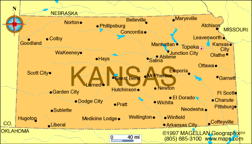
Kansas is a landlocked state in the central United States, bordered by Nebraska, Missouri, Oklahoma, and Colorado. A map of Kansas shows a largely rectangular state defined by wide-open plains, agricultural land, and gently rolling terrain. Its central location has made it an important transportation and farming hub since the 19th century.
Often associated with the Great Plains, Kansas is one of the nation’s leading agricultural producers, particularly of wheat, corn, and beef. The state combines rural landscapes with growing urban centers and a strong connection to American frontier history.
History of Kansas
Kansas was originally inhabited by Native American tribes including the Kansa, Osage, Pawnee, and Wichita peoples. In the mid-1800s, the territory became a focal point in the national debate over slavery, leading to violent conflicts known as Bleeding Kansas.
Kansas was admitted to the Union in 1861 as a free state. Throughout the late 19th and early 20th centuries, railroads and farming shaped settlement and economic growth. Today, Kansas maintains its agricultural roots while expanding industries such as aviation, manufacturing, and renewable energy.
Geography of Kansas
Kansas covers approximately 213,100 square kilometers and is characterized by flat to gently rolling plains. Elevation gradually rises from east to west, with the lowest point near the Missouri border and the highest point at Mount Sunflower near the Colorado border.
Key geographic features include:
-
Great Plains: Cover most of the state
-
Flint Hills: Tallgrass prairie region in east-central Kansas
-
Arkansas River: Major river flowing through southern Kansas
-
Smoky Hills: Rolling terrain in north-central Kansas
Kansas has a continental climate with hot summers, cold winters, and frequent thunderstorms. The state is part of Tornado Alley and experiences a higher number of tornadoes than most U.S. states.
Major Cities
-
Topeka: Capital city and government center
-
Wichita: Largest city and aviation industry hub
-
Kansas City: Major metropolitan area along the Missouri border
-
Overland Park: Large suburban city in Johnson County
-
Olathe: Growing city in the Kansas City metro area
-
Lawrence: College town and cultural center
Facts & Figures About Kansas
-
Area: Approximately 213,100 square kilometers
-
Population: Around 3 million
-
Capital: Topeka
-
Largest City: Wichita
-
Statehood: 1861 (34th state)
-
Nickname: The Sunflower State
-
Major Industries: Agriculture, aviation, manufacturing, energy
-
Climate: Continental with hot summers and cold winters
-
Highest Point: Mount Sunflower
People also ask
Where is Kansas located?
Kansas is located in the central United States, bordered by Nebraska, Missouri, Oklahoma, and Colorado.
What is Kansas known for?
Kansas is known for its agriculture, especially wheat production, its role in U.S. frontier history, and its position in Tornado Alley.
Is Kansas flat?
Much of Kansas is flat or gently rolling, though regions like the Flint Hills and Smoky Hills add variation to the landscape.
What is the capital of Kansas?
The capital of Kansas is Topeka.
|
|
 |


