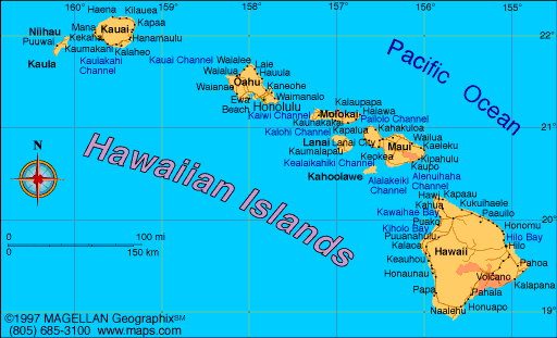
Hawaii is the only U.S. state made up entirely of islands, located in the central Pacific Ocean. It consists of eight main islands and over a hundred smaller islets and atolls. A current map of Hawaii highlights its volcanic origins, tropical ecosystems, and remote location about 2,400 miles from the U.S. mainland.
Tourism, agriculture, and conservation all play major roles in Hawaii’s development. Each island has its own distinct geography, culture, and attractions. From the surf beaches of Oahu to the black sand coastlines of the Big Island, Hawaii remains one of the most visually diverse states in America.
Hawaii Profile
History of Hawaii
Hawaii was originally settled by Polynesian voyagers more than 1,000 years ago. The islands developed their own social structure and religion, with agriculture and fishing at the center of daily life. Captain James Cook arrived in 1778, marking the beginning of Western contact.
In 1810, King Kamehameha I unified the islands into a single kingdom. Hawaii was annexed by the United States in 1898, became a U.S. territory in 1900, and was admitted as the 50th state in 1959. Despite its statehood, Hawaii maintains a strong connection to its Native Hawaiian heritage and cultural identity.
Geography of Hawaii
Hawaii’s geography is shaped entirely by volcanic activity. All of the major islands were formed by undersea volcanoes, with new land still being added through eruptions on the Big Island.
- The Big Island is home to Mauna Loa and Kilauea, two of the most active volcanoes in the world
- Oahu features mountain ranges, protected bays, and dense urban centers
- Maui includes lush valleys, waterfalls, and Haleakalā Crater
- Kauai, the oldest island, is known for its cliffs, canyons, and rainforest
- Molokai, Lanai, Niihau, and Kahoolawe are less populated and more remote
The state has a tropical climate, with distinct wet and dry zones depending on elevation and island orientation. Coastal erosion, coral reef health, and rising sea levels are ongoing environmental concerns.
Major Cities and Towns
- Honolulu – Capital city on Oahu and the state’s economic and cultural center
- Hilo – Historic town on the eastern side of the Big Island
- Kailua-Kona – Popular resort area on the Big Island’s west coast
- Kahului – Commercial hub on Maui
- Lihue – Main town on Kauai and site of the island’s airport
- Waipahu and Pearl City – Residential areas near Honolulu and Pearl Harbor
Facts About Hawaii
- Hawaii is the only U.S. state with two official languages: English and Hawaiian
- It does not observe daylight saving time
- Mauna Kea is taller than Mount Everest when measured from its base on the ocean floor
- The islands were formed over a volcanic hotspot and continue to grow
- Tourism is the top economic sector, followed by agriculture and military spending
- Native Hawaiian culture includes hula, lua (martial arts), and traditional navigation
- It is the most isolated population center on Earth
- Coral reefs and tropical forests support rare and endemic species
People Also Ask
What are the main islands of Hawaii?
The eight main islands are Hawaii (Big Island), Maui, Oahu, Kauai, Molokai, Lanai, Niihau, and Kahoolawe.
What does the Hawaii map show?
It shows the locations and sizes of the main islands, city centers, mountain ranges, volcanoes, roads, beaches, and protected natural areas.
Is Hawaii safe for tourists in 2025?
Yes. Hawaii is one of the safest states in the U.S., with strong infrastructure and a focus on tourism safety and environmental conservation.
What is the geography of Hawaii like?
Hawaii features volcanic peaks, coastal cliffs, rainforests, lava fields, beaches, and coral reefs. Each island has its own geographic makeup based on age and volcanic activity.
|
|
 |


