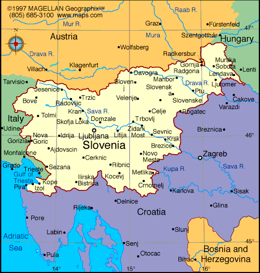
Slovenia is a compact and scenic country in Central Europe, bordered by Italy, Austria, Hungary, and Croatia. A map of Slovenia highlights its unique location at the intersection of the Alps, the Pannonian Basin, and the Adriatic Sea. Despite its size, the country offers a wide range of landscapes including mountains, forests, rivers, and a short but active coastline.
Known for clean cities and strong environmental policies, Slovenia has positioned itself as a sustainable destination. Since its independence in the early 1990s, the country has become a member of the European Union and NATO, with a reputation for safety, green tourism, and a high quality of life.
Slovenia Profile
History of Slovenia
Slovenia’s roots go back to Roman times, when cities like Emona (modern-day Ljubljana) were part of the Roman Empire. Over centuries, the region was ruled by various powers, including the Holy Roman Empire and the Habsburg Monarchy. Despite foreign rule, Slovenians maintained their language and culture.
Following World War I, Slovenia joined the Kingdom of Serbs, Croats, and Slovenes, later known as Yugoslavia. After decades under socialist rule, Slovenia was the first republic to declare independence in 1991. Its transition to a market economy was smooth, and it joined both NATO and the EU in 2004.
Geography of Slovenia
Slovenia covers about 20,200 square kilometers. It offers four major landscape types within a small area:
- Alpine mountains with peaks like Mount Triglav in the northwest
- Karst regions in the southwest with caves and limestone terrain
- Lowlands in the northeast used for agriculture and industry
- Coastal areas along the Adriatic Sea, only about 47 kilometers long
The country also has three major climatic zones: alpine, continental, and Mediterranean. Forests cover more than half of the country, and rivers like the Sava and Drava are essential for transport, energy, and recreation.
Major Cities
- Ljubljana – Capital and cultural hub
- Maribor – Wine-growing and industrial center in the northeast
- Celje – Known for medieval history and economic development
- Kranj – Major business and tech region
- Koper – Slovenia’s port on the Adriatic
- Novo Mesto – Center for pharmaceuticals and auto industry
Facts About Slovenia
- Mount Triglav is the national symbol and appears on the flag
- Lake Bled is one of the most visited spots in the country
- Slovenia ranks high for environmental sustainability and public safety
- The Škocjan Caves are a UNESCO World Heritage Site
- Slovenians are passionate about hiking, skiing, and cycling
- More than 10,000 caves have been documented
- The country uses the euro and is part of the Schengen Zone
- The official language is Slovene
People Also Ask
Where is Slovenia located on the map?
Slovenia is in Central Europe, between Italy, Austria, Hungary, and Croatia, with a small western coastline along the Adriatic Sea.
Is Slovenia in the European Union?
Yes. Slovenia has been a member of the EU since 2004 and also uses the euro as its official currency.
What is Slovenia known for?
Slovenia is known for its natural diversity, including mountains, lakes, caves, and a strong culture of outdoor living.
What language do they speak in Slovenia?
The official language is Slovene. In some regions, Italian and Hungarian are also recognized. English is widely spoken, especially among younger generations.
|
|
 |


