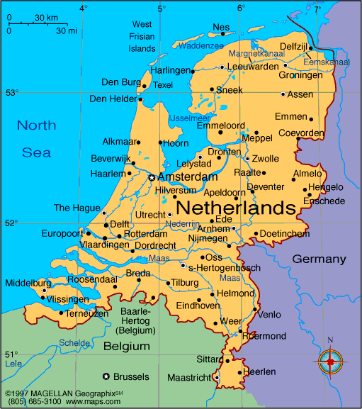
The Netherlands is a low-lying country in northwestern Europe, known for its flat landscape, network of canals, windmills, and dense urban centers. A current map of the Netherlands shows its 12 provinces, key cities like Amsterdam and Rotterdam, and the country’s extensive coastline along the North Sea.
With a population of over 17 million people, the Netherlands is one of the most densely populated countries in Europe. Its efficient infrastructure, planned land use, and strong water management systems make it a global example of urban and environmental planning.
Netherlands Profile
History of the Netherlands
The region now known as the Netherlands has been inhabited since prehistoric times. It became part of the Roman Empire and later developed into a center of trade during the Middle Ages. The Dutch Republic was established in the 16th century after gaining independence from Spain.
The Netherlands became a major maritime and colonial power in the 17th century, known as the Dutch Golden Age. In modern times, it has played a key role in European integration and global trade. It was one of the founding members of the European Union and NATO, and continues to be active in international law, with The Hague hosting several global institutions.
Geography of the Netherlands
The Netherlands covers approximately 41,850 square kilometers. Around a third of the country lies below sea level, protected by an advanced system of dikes, levees, and pumps. The country is famous for reclaiming land from the sea, creating polders used for agriculture, housing, and industry.
- The western region is densely populated with cities and ports
- The north and northeast are more rural, with agricultural fields and lakes
- Rivers like the Rhine, Meuse, and Scheldt flow through the country into the North Sea
- The Wadden Sea and barrier islands line the northern coast
- The climate is temperate oceanic, with mild summers and cool winters
Major Cities
- Amsterdam – Capital city, cultural and economic hub
- Rotterdam – Major port city and center of architecture and shipping
- The Hague – Seat of government and home to international courts
- Utrecht – Central city with medieval core and transport links
- Eindhoven – Known for technology and innovation
- Groningen – University town in the north
- Maastricht – Historic city near the Belgian and German borders
Facts About the Netherlands
- The Netherlands has 12 provinces, each with its own local government
- Over 25% of the land is below sea level
- Dutch is the official language; Frisian is also spoken in Friesland
- The Netherlands is a constitutional monarchy with a parliamentary system
- It is home to one of the world’s busiest ports: the Port of Rotterdam
- The country is known for its tulips, cycling culture, and liberal social policies
- Water management is central to the country's survival and planning
- Dutch people have one of the highest average heights in the world
People Also Ask
What regions are shown on the Netherlands map?
The map highlights all 12 provinces, including North Holland, South Holland, Utrecht, Gelderland, and Friesland, as well as major rivers and coastal zones.
Is the Netherlands mostly below sea level?
Yes. About a third of the country lies below sea level, and it relies on an extensive system of dikes, dams, and polders to stay dry.
What cities are important in the Netherlands?
Amsterdam is the capital, but Rotterdam, The Hague, Utrecht, and Eindhoven are also major cities with national and international importance.
What is the terrain of the Netherlands like?
The country is mostly flat with low elevation, agricultural fields, river deltas, and reclaimed land. It also includes dunes, forests, and wetlands in some regions.
|
|
 |


