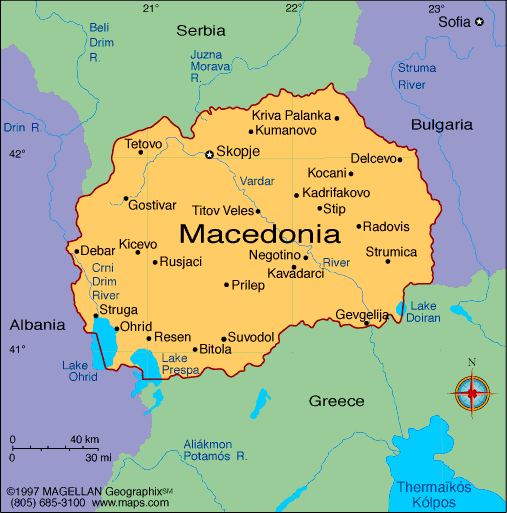
Macedonia, officially known as North Macedonia, is a landlocked country in Southeast Europe on the Balkan Peninsula. A current map of Macedonia shows its mountainous terrain, lakes, and cities like Skopje, Bitola, and Ohrid. The country shares borders with Kosovo, Serbia, Bulgaria, Greece, and Albania.
Although relatively small in area, North Macedonia features a complex landscape and a mix of cultural influences. It became an independent republic in 1991 following the breakup of Yugoslavia and changed its official name in 2019 after resolving a long-standing naming dispute with Greece.
Macedonia Profile
History of Macedonia
The region of Macedonia has been inhabited since ancient times and was once part of the Kingdom of Paeonia and later the Roman and Byzantine empires. It holds historic ties to Alexander the Great and the ancient Macedonian kingdom, though the modern state of North Macedonia is distinct from the Greek region of the same name.
Following centuries of Ottoman rule, the area became part of Yugoslavia after World War II. North Macedonia declared independence in 1991. The country joined NATO in 2020 and continues to pursue European Union membership. Its name change to North Macedonia was formalized through the Prespa Agreement with Greece.
Geography of Macedonia
North Macedonia covers around 25,700 square kilometers. The landscape is dominated by mountains, valleys, and basins, with several large lakes and rivers contributing to its natural beauty and biodiversity.
- The Šar Mountains stretch across the northwest
- Lake Ohrid and Lake Prespa lie on the western border
- The Vardar River runs through the country’s central valley
- The climate is a mix of Mediterranean and continental influences
- Forests, hills, and rugged peaks shape much of the interior
The terrain plays an important role in agriculture, energy, and tourism, particularly in national parks and lake regions.
Major Cities
- Skopje – Capital and largest city, political and economic center
- Bitola – Cultural hub with Ottoman and neoclassical architecture
- Ohrid – Historic town on Lake Ohrid, known for churches and UNESCO status
- Tetovo – Multicultural city in the northwest
- Kumanovo – Industrial and commercial center
- Prilep – Known for tobacco production and stone landmarks
- Strumica – Agricultural and festival-friendly city near the southeast border
Facts About Macedonia
- The country was renamed North Macedonia in 2019
- It is a parliamentary republic with a multiethnic population
- Macedonian is the official language; Albanian is co-official in many areas
- The Cyrillic alphabet is used for writing
- Lake Ohrid is one of Europe’s oldest and deepest lakes
- The country is rich in Byzantine churches, mosques, and ancient ruins
- Agriculture and manufacturing are major parts of the economy
- North Macedonia is a member of NATO and a candidate for EU membership
People Also Ask
What does the Macedonia map show?
It displays the national borders, mountain ranges, valleys, rivers, major lakes, transportation routes, and major cities like Skopje and Bitola.
Is Macedonia landlocked?
Yes. North Macedonia is completely landlocked, with no coastline. It is surrounded by five other countries.
What is the terrain like in North Macedonia?
The country features rugged mountain systems, deep river valleys, fertile plains, and large lakes. Elevation changes are frequent, even within short distances.
What are the most visited places in North Macedonia?
Top destinations include Lake Ohrid, Skopje’s Old Bazaar and fortress, Mavrovo National Park, Bitola’s ancient ruins, and monasteries such as Saint Naum and Treskavec.
|
|
 |


