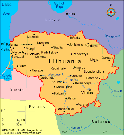
Lithuania is a country in northeastern Europe, one of the three Baltic States, located along the southeastern coast of the Baltic Sea. A map of Lithuania shows its central location bordered by Latvia, Belarus, Poland, and the Russian exclave of Kaliningrad. Known for its flat landscapes, lakes, forests, and river systems, Lithuania offers a unique mix of natural beauty and cultural heritage.
The country is part of the European Union and NATO, and since gaining independence from the Soviet Union in 1990, it has modernized rapidly while preserving its strong national identity. With a population of just over 2.7 million, Lithuania’s cities, towns, and protected natural areas are easy to explore.
Lithuania Profile
History of Lithuania
Lithuania’s recorded history begins in the Middle Ages, and by the 14th century, it had formed one of the largest kingdoms in Europe, the Grand Duchy of Lithuania. It later entered into a dual state with Poland known as the Polish-Lithuanian Commonwealth, which lasted until the late 18th century when the land was absorbed by the Russian Empire.
In 1918, Lithuania declared independence following World War I but was later annexed by the Soviet Union in 1940. After decades of Soviet control, Lithuania became the first Soviet republic to declare independence in March 1990. Today, it is a democratic republic with strong Western ties and a growing economy.
Geography of Lithuania
Lithuania covers an area of about 65,300 square kilometers, with a landscape shaped by glaciers and rivers. The country is mostly flat, featuring lakes, woodlands, wetlands, and low-lying hills.
- Borders: Latvia (north), Belarus (east and south), Poland and Russia (southwest), and the Baltic Sea (west)
- Rivers: The Nemunas is the longest river, flowing into the Curonian Lagoon and the Baltic
- Lakes: Over 3,000 lakes, with Lake Drūkšiai being the largest
- Forests: Roughly 33% of the land is forested
- Climate: Temperate, with cold winters and mild summers
Major Cities
- Vilnius – The capital, known for its Baroque old town and cultural landmarks
- Kaunas – A historic city and industrial hub along the Nemunas River
- Klaipėda – Lithuania’s main port on the Baltic Sea
- Šiauliai – A commercial center in northern Lithuania
- Panevėžys – Known for manufacturing and theater traditions
Facts About Lithuania
- The Lithuanian language is one of the oldest surviving Indo-European languages
- Vilnius University is one of the oldest universities in Eastern Europe
- Lithuania was once part of the largest medieval state in Europe
- It is home to the Hill of Crosses, a famous pilgrimage site
- Basketball is the most popular sport in the country
- Lithuania has one of the fastest public Wi-Fi speeds globally
- The Curonian Spit, a UNESCO site, is shared with Russia and features unique sand dunes and pine forests
- Lithuania celebrates two independence days: February 16 (1918) and March 11 (1990)
People Also Ask
Where is Lithuania located on the map?
Lithuania is in northeastern Europe, between Latvia and Poland, with a western coastline along the Baltic Sea.
Is Lithuania in the EU and NATO?
Yes. Lithuania joined the European Union and NATO in 2004 and uses the euro as its currency.
What language do Lithuanians speak?
The official language is Lithuanian, one of the oldest and most conservative living Indo-European languages.
What are Lithuania’s top tourist destinations?
Vilnius Old Town, Trakai Castle, the Curonian Spit, and the Hill of Crosses are among the most visited landmarks.
|
|
 |


