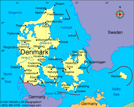
Located in Northern Europe, Denmark sits at the crossroads between the North Sea and the Baltic Sea. A map of Denmark reveals a country made up of the Jutland Peninsula and over 400 islands, including major ones like Zealand, Funen, and Bornholm. Its flat terrain, extensive coastline, and strategic position have shaped its maritime and cultural history.
Denmark is part of Scandinavia and the Nordic region. It’s known for its progressive society, green energy leadership, and a strong welfare state. The capital, Copenhagen, is a hub of design, innovation, and quality of life. With a population of around 6 million, Denmark consistently ranks among the world’s happiest countries.
Denmark Profile
History of Denmark
Denmark’s history stretches back to the Viking Age, when it was one of the dominant powers in Northern Europe. Danish Vikings explored, traded, and settled across wide parts of Europe. The unified kingdom of Denmark emerged in the 10th century, becoming one of the oldest continuous monarchies in the world.
In later centuries, Denmark was part of the Kalmar Union with Sweden and Norway. It later lost many territories during wars and treaties, but retained strong influence in the Baltic region. In the modern era, Denmark remained neutral in both world wars and became a founding member of NATO and the United Nations. Today, it combines historical traditions with modern governance and global engagement.
Geography of Denmark
Denmark covers about 43,000 square kilometers and is largely low-lying. The Jutland Peninsula connects it to Germany, while the rest of the country is composed of islands connected by bridges and ferries.
- The country has over 7,000 kilometers of coastline
- Landscapes include coastal plains, small hills, heathlands, and fertile farmland
- The Øresund Bridge links Copenhagen to Malmö, Sweden
- The North Sea lies to the west, and the Baltic Sea to the east
- The climate is temperate, with mild winters and cool summers
Waterways and wind have shaped Denmark’s geography for centuries. Its flat land and strong winds have made it a global leader in wind energy production.
Major Cities
- Copenhagen – Capital and largest city, center for culture and government
- Aarhus – University city on the east coast of Jutland
- Odense – Located on Funen, birthplace of Hans Christian Andersen
- Aalborg – Industrial and cultural center in northern Jutland
- Esbjerg – Key North Sea port and energy hub
- Roskilde – Historic city known for its cathedral and music festival
Facts About Denmark
- Denmark has more than 400 named islands, but only about 70 are inhabited
- The Danish monarchy dates back over 1,000 years
- Greenland and the Faroe Islands are part of the Kingdom of Denmark but have home rule
- Denmark consistently ranks among the cleanest and greenest countries
- It is one of the world's top exporters of pork and dairy
- Bicycles outnumber cars in Copenhagen
- Danish is the official language and the krone is the currency
- Education and healthcare are free and publicly funded
People Also Ask
Where is Denmark located on the map?
Denmark is in Northern Europe, north of Germany, between the North Sea and the Baltic Sea. It’s part of the Scandinavian region.
Is Denmark part of Scandinavia or the EU?
Denmark is both a Scandinavian country and a member of the European Union. However, it does not use the euro and keeps the Danish krone.
What is Denmark known for?
Denmark is known for its design, sustainability, cycling culture, welfare model, and historic monarchy.
What language do people speak in Denmark?
The official language is Danish. Many Danes also speak English fluently, especially in urban areas.
|
|
 |


