Western Sahara Profile
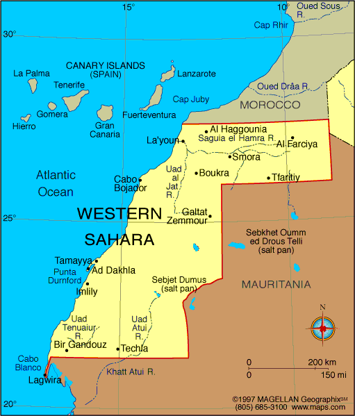
Western Sahara is a disputed territory located on the northwest coast of Africa, bordered by Morocco, Algeria, Mauritania, and the Atlantic Ocean. The region is characterized by its arid desert landscape and long-running political conflict over its sovereignty.
Claimed by the Sahrawi Arab Democratic Republic (SADR) but mostly controlled by Morocco, Western Sahara remains one of the most contested regions in the world. Despite its uncertain status, the territory is home to several towns, a sparse population, and significant phosphate reserves.
History of Western Sahara
Historically inhabited by Sahrawi nomads, Western Sahara was colonized by Spain in the late 19th century. After Spain's withdrawal in 1975, both Morocco and Mauritania laid claim to the area. A guerrilla war followed, led by the Polisario Front, which declared the Sahrawi Arab Democratic Republic and fought for independence.
Mauritania withdrew its claim in 1979, but Morocco annexed most of the territory. Since then, Morocco has administered the majority of the land, while the Polisario Front continues to push for independence. A UN-brokered ceasefire was reached in 1991, though the political status remains unresolved, and peace talks continue.
Geography of Western Sahara
Western Sahara spans roughly 266,000 square kilometers, consisting mostly of flat, sandy desert. It lies between latitudes 20° and 28°N and is part of the greater Sahara Desert ecosystem. The landscape features dunes, rocky plateaus, and dry wadis (riverbeds), with very little vegetation or permanent water sources.
The climate is hot and arid, with extreme temperature variations and minimal rainfall. Coastal areas benefit slightly from Atlantic breezes, while the interior is harsh and sparsely populated.
Natural resources include vast phosphate deposits near Bou Craa and potential offshore oil reserves, though development has been limited by the unresolved political situation.
Facts & Figures About Western Sahara
-
Area: Approximately 266,000 square kilometers
-
Population: Estimated 500,000 (including Moroccan settlers)
-
Capital (SADR): Laayoune (claimed)
-
Largest City: Laayoune (administered by Morocco)
-
Borders: Morocco, Mauritania, Algeria, Atlantic Ocean
-
Official Languages: Arabic (SADR); Moroccan Arabic, Hassaniya
-
Currency: Moroccan dirham (MAD) in administered areas
-
Main Exports: Phosphate, fish, and potentially oil
-
Governing Bodies: Morocco (de facto); SADR/Polisario Front (claimed)
Major Towns and Settlements
-
Laayoune – The largest city, regional capital, and administrative center under Moroccan control
-
Dakhla – Coastal city known for fishing, tourism, and kite surfing
-
Smara – Inland town with Sahrawi cultural significance
-
Bou Craa – Site of major phosphate mining operations
-
Tifariti – Located in the Polisario-controlled zone, used for SADR government events
People also ask…
What is the political status of Western Sahara?
Western Sahara is considered a non-self-governing territory by the UN. It is mostly administered by Morocco, while the Polisario Front claims it as the independent Sahrawi Arab Democratic Republic.
Is Western Sahara safe to visit?
While major cities like Laayoune and Dakhla are relatively safe under Moroccan administration, travel in border regions and areas east of the Moroccan Wall is discouraged due to military presence and landmines.
What is the economy of Western Sahara based on?
The economy relies heavily on fishing, phosphate mining, and public sector employment. Development is limited due to the political dispute and lack of international recognition.
|
|
 |


