Niger Profile
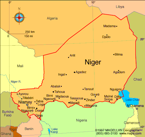
Niger is a landlocked country in West Africa bordered by Algeria, Libya, Chad, Nigeria, Benin, Burkina Faso, and Mali. A map of Niger shows a vast country dominated by desert and semi desert landscapes, with population centers concentrated in the south and along major rivers. Much of Niger lies within the Sahara Desert, making it one of the driest countries in the region.
Niamey, the capital and largest city, is located along the Niger River and serves as the country’s political, economic, and cultural center.
History of Niger
The territory of present day Niger has been inhabited for thousands of years and was part of important trans Saharan trade routes. Ancient kingdoms and empires such as the Kanem Bornu Empire and the Songhai Empire influenced the region through trade, religion, and culture.
France established colonial rule in the late 19th century, and Niger became part of French West Africa. The country gained independence in 1960. Since independence, Niger has faced economic challenges and periods of political change while maintaining strong cultural traditions across its diverse ethnic groups.
Geography of Niger
Niger covers approximately 1.27 million square kilometers and is one of the largest countries in Africa by land area.
Key geographic features include:
-
Sahara Desert: Covers much of northern Niger
-
Sahel Zone: Semi arid region across central Niger
-
Niger River: Major water source in the southwest
-
Aïr Mountains: Mountain range in the north central region
-
Lake Chad Basin: Southeastern region near the Chad border
The climate is mostly hot and dry, with extremely high temperatures in the desert regions and limited rainfall concentrated in the south.
Major Cities
-
Niamey: Capital and largest city
-
Zinder: Historic city and former capital
-
Maradi: Major commercial center near the Nigerian border
-
Agadez: Key city in northern Niger and gateway to the Sahara
-
Tahoua: Regional center in central Niger
-
Diffa: Southeastern city near Lake Chad
Facts & Figures About Niger
-
Area: Approximately 1.27 million square kilometers
-
Population: Around 27 million
-
Capital: Niamey
-
Official Language: French
-
Other Languages: Hausa, Zarma, Tuareg, Fulfulde
-
Currency: West African CFA franc (XOF)
-
Independence: 1960 from France
-
Climate: Hot desert and semi arid
-
Main Industries: Agriculture, livestock, uranium mining
People also ask
Where is Niger located?
Niger is located in West Africa and is bordered by seven countries, with no coastline.
What is Niger known for?
Niger is known for its desert landscapes, Tuareg culture, uranium resources, and role in trans Saharan trade history.
What language is spoken in Niger?
French is the official language. Hausa and Zarma are widely spoken across the country.
Is Niger mostly desert?
Yes. Much of Niger lies within the Sahara Desert, especially in the northern regions.
|
|
 |


