Namibia Profile
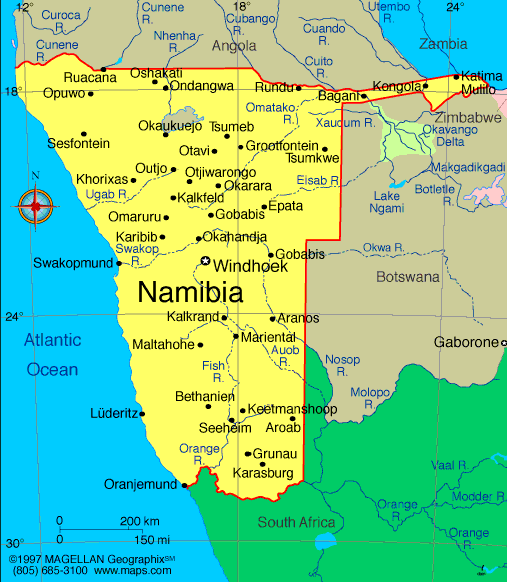
Namibia is a country in southwestern Africa bordered by Angola, Zambia, Botswana, and South Africa, with a long coastline along the Atlantic Ocean. A map of Namibia highlights vast desert landscapes, including the Namib Desert along the coast and the Kalahari region in the east, as well as river valleys and the northern highlands. Namibia’s unique geography and sparse population make it a standout destination for outdoor adventure and wildlife tourism.
Namibia is known for its political stability, significant natural resources, and commitment to conservation. Its terrain supports diverse ecosystems, from desert dunes and rugged mountains to floodplains and savannas.
History of Namibia
The region now known as Namibia has been inhabited for millennia by indigenous groups, including the San, Herero, and Ovambo peoples. In the late 19th century, it became a German colony called German South West Africa. After World War I, it came under South African administration, which enforced apartheid policies.
Namibia embarked on a long struggle for independence, led by the South West Africa People’s Organization (SWAPO). The country finally gained independence in 1990 with a constitution that emphasized democracy and human rights. Since then, Namibia has maintained relative stability and has built a reputation for environmental protection and tourism.
Geography of Namibia
Namibia covers about 825,000 square kilometers and is one of the most sparsely populated countries in the world. The landscape is dominated by desert and semi‑desert areas, dramatic sand dunes, and rugged terrain.
-
Namib Desert: A coastal desert with some of the tallest sand dunes on Earth
-
Skeleton Coast: Harsh, foggy coastline with shipwrecks and wildlife
-
Etosha Basin: A large seasonal salt pan that supports diverse wildlife
-
Caprivi Strip: A narrow extension in the northeast with rivers and wetlands
-
Kaokoveld: Arid region in the northwest with unique desert adapted species
The climate ranges from arid and semi‑arid in the desert interior to subtropical in the far northeast. Rainfall is low and highly variable, shaping both human settlement and wildlife patterns.
Major Cities
-
Windhoek: Capital and largest city, administrative and economic center
-
Swakopmund: Coastal city known for German colonial architecture and adventure tourism
-
Walvis Bay: Major port and fishing hub on the Atlantic coast
-
Rundu: River town in the northeast near the Angola border
-
Oshakati: Key urban center in northern Namibia
-
Keetmanshoop: Southern regional hub near desert landscapes
Facts & Figures About Namibia
-
Area: Approximately 825,000 square kilometers
-
Population: Around 2.6 million
-
Capital: Windhoek
-
Official Language: English
-
Other Languages: Oshiwambo, Nama, Afrikaans, German and others
-
Currency: Namibian dollar (NAD)
-
Independence: Gained from South Africa in 1990
-
Climate: Mostly arid to semi‑arid
-
Main Industries: Mining (diamonds, uranium), tourism, agriculture
People also ask…
Where is Namibia located on the map?
Namibia is in southwestern Africa, bordered to the west by the Atlantic Ocean and surrounded by Angola, Zambia, Botswana, and South Africa.
What is Namibia known for?
Namibia is known for its deserts, especially the Namib and Kalahari, its wildlife and national parks such as Etosha, and its dramatic landscapes including the Skeleton Coast.
What language is spoken in Namibia?
English is the official language. Other widely spoken languages include Oshiwambo, Nama/Damara, Afrikaans, and German.
Is Namibia a safe place to visit?
Yes, Namibia is generally considered safe for travelers, with a well‑developed tourism infrastructure and stable political environment. Standard safety precautions are recommended.
|
|
 |


