Mauritius Profile
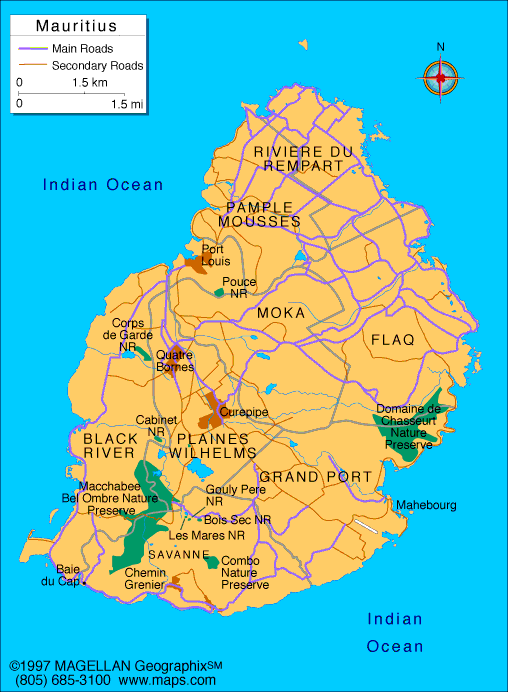
Mauritius is an island country located in the Indian Ocean, east of Madagascar and southeast of the African mainland. A map of Mauritius shows a compact volcanic island surrounded by coral reefs, with a mix of coastal plains, rolling hills, and a central plateau. Despite its small size, Mauritius has a diverse landscape and a highly developed infrastructure.
The country is known for its beaches, lagoons, and multicultural society shaped by African, Asian, and European influences. Mauritius is also recognized for its political stability and strong economy compared to many island nations.
History of Mauritius
Mauritius was uninhabited until the arrival of Europeans in the 16th century. The Portuguese were the first to visit, followed by Dutch settlement in the 1600s. The island later came under French control and then British rule in 1810.
Mauritius gained independence from the United Kingdom in 1968 and became a republic in 1992. Since independence, the country has transitioned from a sugar based economy to a diversified one, including tourism, finance, and manufacturing.
Geography of Mauritius
Mauritius covers approximately 2,040 square kilometers and is of volcanic origin. The island features a central plateau surrounded by lower coastal plains and mountain ranges.
Key geographic features include:
-
Central Plateau: Elevated interior with cooler temperatures
-
Mountain Ranges: Including Black River Gorges and Moka Range
-
Coastal Plains: Flat areas where most towns and resorts are located
-
Coral Reefs: Surround much of the island, forming lagoons
-
Rivers and Waterfalls: Short rivers flowing from the plateau to the sea
The climate is tropical, with a warm and humid summer season and a cooler, drier winter. Cyclones can occur during the summer months.
Major Cities
-
Port Louis – Capital city and main port
-
Beau Bassin–Rose Hill – Large urban area in the northwest
-
Vacoas–Phoenix – Located on the central plateau
-
Curepipe – Elevated city with cooler climate
-
Quatre Bornes – Commercial and residential hub
-
Mahébourg – Historic town near the southeastern coast
Facts & Figures About Mauritius
-
Area: Approximately 2,040 square kilometers
-
Population: Around 1.3 million
-
Capital: Port Louis
-
Official Language: English
-
Widely Spoken Languages: French, Mauritian Creole
-
Currency: Mauritian rupee (MUR)
-
Independence: 1968 from the United Kingdom
-
Government Type: Republic
-
Main Industries: Tourism, financial services, manufacturing, agriculture
People also ask
Where is Mauritius located?
Mauritius is located in the Indian Ocean, east of Madagascar and southeast of mainland Africa.
What is Mauritius known for?
Mauritius is known for its beaches, coral reefs, multicultural population, and strong tourism and financial sectors.
Is Mauritius part of Africa?
Geographically, Mauritius is part of Africa, though it is located far offshore in the Indian Ocean.
What language is spoken in Mauritius?
English is the official language, while French and Mauritian Creole are widely spoken in daily life.
|
|
 |


