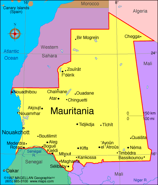
Mauritania is located in northwest Africa, bordered by the Atlantic Ocean to the west and stretching deep into the Sahara Desert. A map of Mauritania reveals a vast, arid land that connects North Africa with sub-Saharan West Africa. The country serves as a cultural and geographic bridge between Arab and African worlds.
Its landscape is dominated by sand dunes, rocky plateaus, and dry plains, with most of the population living near the Atlantic coast. Though sparsely populated, Mauritania has a rich nomadic heritage and deep Islamic traditions. Its capital, Nouakchott, serves as the political and economic center.
Mauritania Profile
History of Mauritania
Mauritania's early history includes Berber and Arab influences, with Islamic expansion reaching the region in the 8th century. It later became part of powerful West African empires like Ghana and Almoravid. French colonial rule began in the early 20th century, and Mauritania gained independence from France in 1960.
Since then, the country has experienced periods of military rule, political shifts, and social challenges, including issues of ethnic tension and slavery. However, democratic processes have been slowly taking hold in recent years, with efforts toward modernization and development.
Geography of Mauritania
Mauritania covers over 1 million square kilometers, most of it desert. It shares borders with Western Sahara, Algeria, Mali, and Senegal. The country can be divided into four main zones:
- Saharan North – Sand dunes and rocky plateaus dominate this largely uninhabited region
- Central Steppe – Transitional zone with seasonal grazing
- Sahel South – More rainfall, supporting agriculture and settlements
- Coastal Plains – Location of the capital and most major cities
The Senegal River forms the southern border, providing a vital water source. The Banc d’Arguin National Park, on the Atlantic coast, is a UNESCO site known for bird migration and marine life.
Major Cities
- Nouakchott – Capital and largest city, located on the west coast
- Nouadhibou – Important port and fishing center near the northern border
- Zouerate – Mining town known for iron ore
- Kiffa – Located in the south, known for trade and crafts
- Rosso – Border city on the Senegal River
- Atar – Inland town and tourism gateway to the Adrar region
Facts About Mauritania
- About 90 percent of the land is desert or semi-desert
- Arabic is the official language, along with national languages like Pulaar, Soninke, and Wolof
- Islam is the state religion and central to cultural life
- Mauritania has one of the world’s richest offshore fishing zones
- Iron ore accounts for nearly half of the country’s exports
- Slavery was officially abolished in 1981, but remnants still impact society
- The country is part of both the Arab League and African Union
People Also Ask
Where is Mauritania located on the map?
Mauritania is in northwest Africa, bordered by the Atlantic Ocean, Western Sahara, Algeria, Mali, and Senegal.
What is the capital of Mauritania?
Nouakchott is the capital and largest city, located near the Atlantic coast.
What is Mauritania known for?
It is known for its desert landscapes, Islamic culture, mineral resources, and its position between Arab and West African regions.
What is the official language of Mauritania?
Arabic is the official language, though several African languages are spoken as well.
|
|
 |


