Madagascar Profile
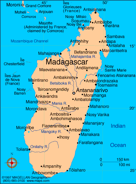
Madagascar is a large island country located in the Indian Ocean off the southeastern coast of Africa. A map of Madagascar shows the world’s fourth largest island, separated from the African mainland by the Mozambique Channel. Its long isolation has resulted in unique wildlife, landscapes, and ecosystems found nowhere else on Earth.
The country features a mix of coastal plains, high plateaus, rainforests, and dry regions. Antananarivo, the capital, is located in the central highlands and serves as the political and economic center of Madagascar.
History of Madagascar
Madagascar was first settled by Austronesian seafarers, followed by African migrants, creating a distinct cultural and linguistic blend. Over time, powerful kingdoms emerged, most notably the Merina Kingdom in the central highlands.
France colonized Madagascar in 1896, and the country gained independence in 1960. Since independence, Madagascar has experienced periods of political instability and reform. Despite challenges, the nation remains deeply connected to its cultural traditions and natural heritage.
Geography of Madagascar
Madagascar covers approximately 587,041 square kilometers and has one of the most diverse natural environments in the world.
Key geographic features include:
-
Central Highlands: Elevated plateau with cooler temperatures
-
Eastern Rainforests: Dense tropical forests with high rainfall
-
Western Plains: Dry lowlands and deciduous forests
-
Southern Region: Semi arid landscapes and spiny forests
-
Rivers: Mangoky, Betsiboka, and Tsiribihina Rivers
The climate ranges from tropical along the coasts to temperate in the highlands, with a rainy season from November to April.
Major Cities
-
Antananarivo: Capital and largest city
-
Toamasina: Major port city on the east coast
-
Antsirabe: High altitude city in the central region
-
Mahajanga: Coastal city in the northwest
-
Toliara: Port city in the southwest
-
Fianarantsoa: Cultural and educational center
Facts & Figures About Madagascar
-
Area: 587,041 square kilometers
-
Population: Around 30 million
-
Capital: Antananarivo
-
Official Languages: Malagasy and French
-
Currency: Malagasy ariary (MGA)
-
Independence: 1960 from France
-
Climate: Tropical to temperate
-
Main Industries: Agriculture, mining, tourism, fishing
-
Biodiversity: Over 90 percent of wildlife is endemic
People also ask
Where is Madagascar located?
Madagascar is located in the Indian Ocean off the southeastern coast of Africa, separated from Mozambique by the Mozambique Channel.
What is Madagascar known for?
Madagascar is known for its unique wildlife, including lemurs, baobab trees, and ecosystems found nowhere else on Earth.
What language is spoken in Madagascar?
Malagasy and French are the official languages. Malagasy is widely spoken across the country.
Is Madagascar safe to visit?
Madagascar is generally safe for visitors, though travelers should take standard precautions and stay informed about local conditions.
|
|
 |


