Eritrea Profile
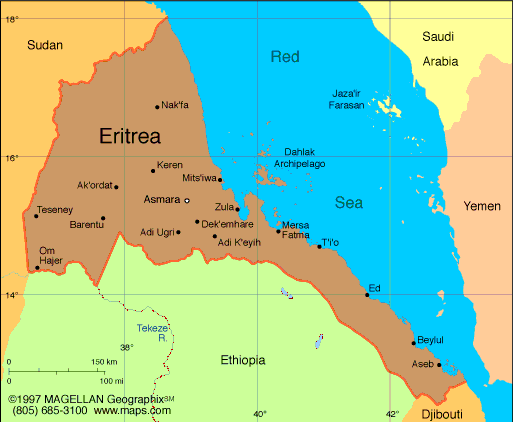
Eritrea is located in the Horn of Africa, bordered by Sudan, Ethiopia, and Djibouti, with an extensive coastline along the Red Sea. Its strategic position along key maritime routes has long shaped its geopolitical and cultural identity. The country’s name is derived from the ancient Greek word for the Red Sea, "Erythra Thalassa."
Despite its modest size, Eritrea features a diverse terrain including coastal plains, rugged mountains, and semi-arid plateaus. Its location has made it historically significant, while its independence and development path give it a distinct presence in the region.
History of Eritrea
The region now known as Eritrea has been part of various powerful kingdoms including the ancient Aksumite Empire. During the late 19th century, it became an Italian colony, and later came under British administration following World War II.
In 1952, Eritrea was federated with Ethiopia, but tensions over autonomy led to a 30-year war for independence. Eritrea officially gained independence in 1993 following a UN-supervised referendum.
Since then, Eritrea has remained under a highly centralized government. Its history is marked by resilience, cultural pride, and a strong emphasis on self-reliance.
Geography of Eritrea
Eritrea spans approximately 117,600 square kilometers and includes three main geographic zones: the eastern coastal plain along the Red Sea, the central highlands, and the western lowlands.
The highlands, which include the capital Asmara, are temperate and support agriculture, while the coast is hot and arid. The Danakil Depression in the southeast is one of the hottest places on Earth. The country also includes more than 350 islands in the Dahlak Archipelago.
Key rivers such as the Gash and Barka run through the western lowlands, which are mostly dry savannas. Eritrea’s varied geography influences its climate zones, natural resources, and settlement patterns.
Facts & Figures About Eritrea
-
Area: 117,600 square kilometers
-
Population: Approximately 3.6 million
-
Capital: Asmara
-
Borders: Sudan, Ethiopia, Djibouti
-
Coastline: Over 1,200 kilometers along the Red Sea
-
Official Languages: Tigrinya, Arabic, English
-
Currency: Nakfa (ERN)
-
Major Exports: Gold, livestock, textiles, food products
-
Terrain: Highlands, coastal plains, lowlands, islands
Major Cities
-
Asmara - Capital city known for Italian colonial architecture
-
Massawa - Port city with historic Ottoman influence
-
Assab - Strategic port in the southern Red Sea region
-
Keren - Agricultural and market town in the highlands
-
Tesseney - Trade hub near the Sudanese border
People also ask…
What is Eritrea known for?
Eritrea is known for its rich history, Red Sea coastline, Italian-influenced capital city, and long struggle for independence. It also has unique architecture, diverse cultures, and a strong national identity.
Is Eritrea safe to visit?
Travel conditions vary. While some areas are peaceful, others have travel restrictions. Visitors should check government advisories before planning trips.
What is the climate like in Eritrea?
Eritrea’s climate varies by region. The coastal areas are hot and dry, the central highlands are temperate, and the western lowlands are semi-arid.
|
|
 |


