Djibouti Profile
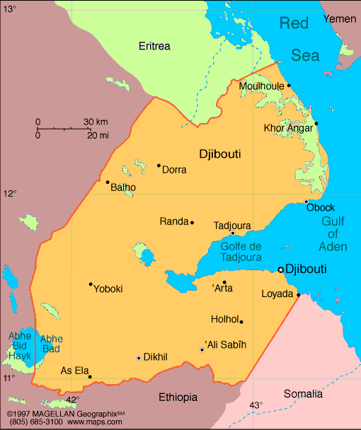
Djibouti is a small country located in the Horn of Africa, bordered by Eritrea, Ethiopia, and Somalia, with a coastline along the Red Sea and the Gulf of Aden. A map of Djibouti highlights its strategic position near the Bab el Mandeb Strait, one of the world’s most important shipping routes connecting the Red Sea to the Indian Ocean.
Despite its size, Djibouti plays an outsized role in global trade and regional security. Its ports serve as a vital gateway for landlocked Ethiopia, and its location has attracted several foreign military bases. The country’s landscape is shaped by volcanic activity, desert plains, and coastal waters.
History of Djibouti
Djibouti’s region has long been inhabited by Afar and Somali peoples, who relied on trade, herding, and maritime connections across the Red Sea. In the late 19th century, France established control over the territory, naming it French Somaliland and later the French Territory of the Afars and the Issas.
After a period of political reform and referendums, Djibouti gained independence from France in 1977. Since independence, the country has maintained relative stability compared to its neighbors and has focused on developing its port infrastructure and service-based economy.
Geography of Djibouti
Djibouti covers approximately 23,200 square kilometers and is dominated by arid and semi-arid terrain. Much of the country lies within the Afar Triangle, a geologically active region where tectonic plates meet.
Key geographic features include:
-
Lake Assal: The lowest point in Africa and one of the saltiest lakes in the world
-
Gulf of Tadjoura: An extension of the Red Sea that cuts into the country
-
Volcanic Plateaus: Evidence of ongoing tectonic activity
-
Desert Plains: Sparse vegetation and extreme temperatures
Djibouti has a hot desert climate, with very high summer temperatures and minimal rainfall. Coastal areas are humid, while inland regions are dry and harsh.
Major Cities
-
Djibouti City: Capital and largest city, home to the main port and most of the population
-
Ali Sabieh: Important inland city near the Ethiopian border
-
Tadjoura: Historic port city on the Gulf of Tadjoura
-
Obock: Coastal town near the entrance to the Red Sea
-
Dikhil: Regional center in the southwest
Facts & Figures About Djibouti
-
Area: Approximately 23,200 square kilometers
-
Population: Around 1 million
-
Capital: Djibouti City
-
Official Languages: French and Arabic
-
Other Languages: Somali and Afar
-
Currency: Djiboutian franc (DJF)
-
Independence: 1977 from France
-
Climate: Hot desert climate
-
Key Industries: Port services, logistics, trade, foreign military presence
People also ask
Where is Djibouti located?
Djibouti is located in the Horn of Africa, along the Red Sea and Gulf of Aden, near the Bab el Mandeb Strait.
Why is Djibouti important?
Djibouti is important due to its strategic location on major global shipping routes and its role as a key port for Ethiopia.
What language is spoken in Djibouti?
French and Arabic are the official languages. Somali and Afar are widely spoken among the population.
Is Djibouti safe to visit?
Djibouti is generally considered stable, though its extreme climate and regional security environment mean travelers should stay informed and take standard precautions.
|
|
 |


