Burundi Profile
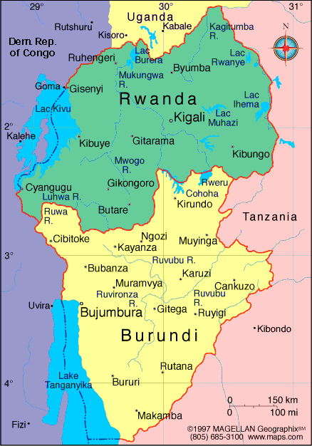
Burundi is a landlocked country in East Africa bordered by Rwanda, Tanzania, and the Democratic Republic of the Congo. A map of Burundi shows a compact nation with rolling hills, high plateaus, and large freshwater lakes. Despite its small size, Burundi has one of the highest population densities in Africa.
The country lies within the African Great Lakes region and has a long history shaped by agriculture, regional trade, and cultural traditions. Gitega is the political capital, while Bujumbura remains the largest city and main economic center.
History of Burundi
Burundi was historically ruled by a centralized kingdom led by a monarch, with social structures that developed over centuries. The kingdom maintained relative independence until the late 19th century, when the territory became part of German East Africa.
After World War I, Burundi came under Belgian administration as part of Ruanda Urundi. The country gained independence in 1962. Its post independence history has included periods of political instability and conflict, followed by peace efforts and reforms aimed at long term stability and development.
Geography of Burundi
Burundi covers approximately 27,834 square kilometers and is characterized by hilly terrain and fertile land.
Key geographic features include:
-
Central Plateau: Rolling highlands used for farming
-
Lake Tanganyika: Forms much of the western border and is one of the deepest lakes in the world
-
Rift Valley Escarpment: Steep slopes descending toward the lake
-
River Systems: Source region of the Nile River tributaries
-
Savanna and Farmland: Dominant land use across the country
Burundi has a tropical highland climate, with moderate temperatures due to elevation and two main rainy seasons.
Major Cities
-
Gitega: Political capital
-
Bujumbura: Largest city and main port on Lake Tanganyika
-
Ngozi: Regional center in northern Burundi
-
Rumonge: Port town along Lake Tanganyika
-
Muyinga: Major city in the northeast
Facts & Figures About Burundi
-
Area: 27,834 square kilometers
-
Population: Around 13 million
-
Capital: Gitega
-
Largest City: Bujumbura
-
Official Languages: Kirundi, French, English
-
Currency: Burundian franc (BIF)
-
Independence: 1962 from Belgium
-
Climate: Tropical highland
-
Main Industries: Agriculture, coffee production, trade
People also ask
Where is Burundi located?
Burundi is located in East Africa, bordered by Rwanda, Tanzania, and the Democratic Republic of the Congo.
What is Burundi known for?
Burundi is known for its hilly landscapes, Lake Tanganyika shoreline, and strong agricultural traditions.
Is Burundi landlocked?
Yes. Burundi does not have a coastline but has access to Lake Tanganyika for transport and fishing.
What language is spoken in Burundi?
Kirundi is the national language. French and English are also official languages.
|
|
 |


