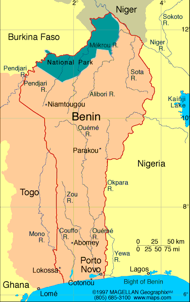
Benin is a narrow, west African country with a southern coastline along the Bight of Benin. Its shape stretches northward toward the Sahel, bordered by Nigeria, Togo, Burkina Faso, and Niger. Benin is rich in culture and history, notably as the location of the ancient Kingdom of Dahomey, and features a wide range of landscapes, from coastal lagoons to semi-arid savannahs.
Though small in size, Benin holds a significant place in the region due to its strategic location, biodiversity, and long-standing cultural traditions. Its economy relies heavily on agriculture, regional trade, and growing port activity through Cotonou.
Benin Profile
History of Benin
The area now known as Benin was once home to powerful pre-colonial states, most notably the Kingdom of Dahomey, which thrived from the 17th to 19th centuries. The kingdom was known for its organized military, including the famed all-female warrior unit, and for being heavily involved in the Atlantic slave trade.
In the late 1800s, France colonized the region, integrating it into French West Africa. The country gained independence in 1960 under the name Dahomey, later changing its name to the Republic of Benin in 1975.
Post-independence, Benin experienced periods of political instability before transitioning to democracy in the 1990s. Today, it is recognized for its relatively stable governance and growing investment in education and infrastructure.
Geography of Benin
Benin spans approximately 114,763 square kilometers. Its geography is generally flat, with a low coastal region in the south, a plateau zone in the center, and drier, semi-arid conditions in the north.
The southern coastline includes lagoons and sandy beaches, while central Benin features fertile lands used for crops like maize, yams, and cotton. In the far north, savannahs dominate the landscape, and the Atacora Mountains rise near the border with Togo.
Rivers such as the Ouémé, Mono, and Niger support agriculture and serve as natural transport routes.
Facts & Figures About Benin
- Area: 114,763 square kilometers
- Population: Around 13.5 million
- Capital: Porto-Novo (official), Cotonou (de facto seat of government)
- Official Language: French
- Other Languages: Fon, Yoruba, Bariba, and others
- Currency: West African CFA franc (XOF)
- Independence: Gained from France in 1960
- Major Exports: Cotton, cashew nuts, palm oil, textiles
Major Cities
- Cotonou – Largest city and economic hub
- Porto-Novo – Capital city and historical center
- Parakou – Key northern trade and transport city
- Abomey – Former capital of the Dahomey Kingdom
- Bohicon – Industrial town with access to transport routes
- Natitingou – Base for travel to national parks and Atacora Mountains
People also ask…
What is Benin known for?
Benin is known for the Kingdom of Dahomey, its voodoo religious traditions, and its history as a center of the Atlantic slave trade. It is also recognized for its stable democracy and vibrant culture.
Is Benin safe to visit?
Benin is generally considered one of the safer countries in West Africa for travelers. However, visitors should stay informed on local conditions and follow government travel advisories.
What languages are spoken in Benin?
French is the official language. Indigenous languages such as Fon, Yoruba, and Bariba are widely spoken across different regions.
|
|
 |


