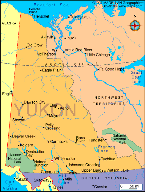
The Yukon Territory, located in northwestern Canada, is known for its vast wilderness, dramatic landscapes, and rich Indigenous and gold rush history. Bordered by Alaska to the west, British Columbia to the south, and the Northwest Territories to the east, Yukon is a sparsely populated region with breathtaking natural beauty and a strong cultural heritage.
The territory spans over 480,000 square kilometers, yet is home to fewer than 50,000 residents, most of whom live in the capital city of Whitehorse. Known for its mountains, forests, rivers, and Arctic tundra, Yukon draws adventurers, historians, and nature lovers alike.
Yukon Territory Profile
History of Yukon Territory
Yukon's history is deeply tied to Indigenous peoples, including the Hän, Gwich'in, and Southern Tutchone, who have lived in the region for thousands of years. Their cultures, traditions, and connection to the land remain vital to the territory today.
The Klondike Gold Rush of the late 1890s brought global attention to the region as tens of thousands of prospectors arrived in search of fortune. Dawson City became a bustling hub during this time. In 1898, Yukon was officially designated as a separate territory from the Northwest Territories to manage the rapid influx of settlers and economic activity.
Today, the territory balances modernization with preservation, showcasing both its historical legacy and natural landscapes.
Geography of Yukon
Yukon's geography includes rugged mountain ranges like the Saint Elias Mountains, home to Canada’s highest peak, Mount Logan. The territory also features boreal forests, glacier-fed rivers like the Yukon River, and parts of the Arctic Circle in the north.
The climate varies greatly depending on the region, with long, cold winters and short, mild summers. The southern areas experience more moderate temperatures compared to the Arctic-influenced north.
Kluane National Park and Reserve is one of the territory's most visited landmarks, known for its glaciers, hiking trails, and wildlife including grizzly bears, moose, and caribou.
Facts & Figures About Yukon
- Area: Approximately 482,443 square kilometers
- Population: Around 45,000
- Capital City: Whitehorse
- Other Towns: Dawson City, Watson Lake, Carmacks, Haines Junction
- Official Languages: English and French (with Indigenous languages also spoken)
- Currency: Canadian Dollar (CAD)
- Climate: Subarctic to Arctic, depending on location
- Key Natural Features: Yukon River, Mount Logan, Kluane National Park
- Main Industries: Mining, tourism, government services, renewable energy
Major Towns and Communities
- Whitehorse: Capital and largest city; administrative and economic center
- Dawson City: Historic heart of the Klondike Gold Rush
- Watson Lake: Known for the Sign Post Forest and its role as a gateway to the north
- Haines Junction: A base for visiting Kluane National Park
- Carmacks and Mayo: Smaller towns along the Yukon River
People also ask…
What is the Yukon Territory known for?
The Yukon Territory is best known for the Klondike Gold Rush, dramatic natural landscapes, and vast wilderness perfect for outdoor adventure.
What language is spoken in Yukon?
English is the most widely spoken language, followed by French. Indigenous languages such as Gwich’in, Southern Tutchone, and Northern Tutchone are also part of the region’s cultural fabric.
Is Yukon part of Alaska or Canada?
Yukon is part of Canada. It borders Alaska but is one of the three federal territories of Canada, with its own government and capital in Whitehorse.
;
|
|
 |


