Nunavut Profile
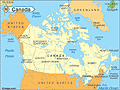
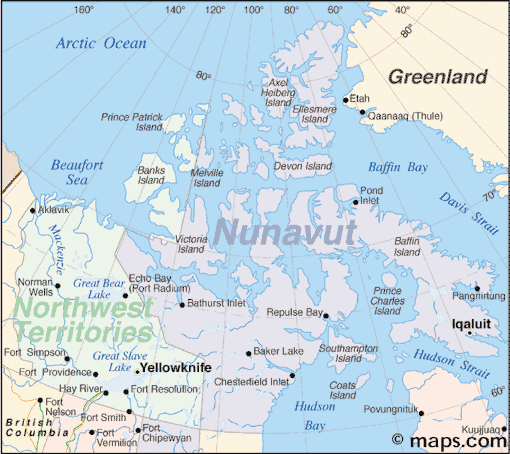
Nunavut is Canada’s largest and northernmost territory, officially separated from the Northwest Territories in 1999. A map of Nunavut reveals a massive expanse of Arctic land and islands, covering nearly one-fifth of Canada’s total area. It stretches from mainland tundra to icy archipelagos, including Baffin Island, Ellesmere Island, and part of Victoria Island.
Despite its size, Nunavut has one of the smallest populations in Canada, with communities spread across isolated settlements accessible mostly by air. It is a region deeply tied to Indigenous Inuit culture and traditions, shaped by the challenging Arctic environment.
History of Nunavut
The Inuit have lived in what is now Nunavut for thousands of years, developing a resilient culture rooted in the land, sea, and ice. European contact began in the 1500s, but colonization remained limited due to the region’s remoteness and harsh climate.
The movement for Inuit self-determination led to the 1993 Nunavut Land Claims Agreement, one of the largest Indigenous land settlements in Canadian history. Nunavut officially became a territory on April 1, 1999, granting the Inuit greater autonomy in governance and preservation of culture.
Today, Nunavut represents a key step in recognizing Indigenous rights and remains a place where traditional lifestyles and modern development intersect.
Geography of Nunavut
Nunavut spans over 2 million square kilometers, comprising mainland tundra and hundreds of Arctic islands. It borders Manitoba, the Northwest Territories, Hudson Bay, and the Arctic Ocean.
-
Baffin Island: Largest island in Canada and home to the capital
-
Ellesmere Island: Northernmost inhabited area in Canada
-
Hudson Bay Lowlands: Southern edge of the territory
-
Arctic Archipelago: Includes remote and glaciated islands
-
Tundra Terrain: Characterized by permafrost, low vegetation, and minimal tree cover
The region has an Arctic climate, with long, dark winters and short, cool summers. Wildlife includes polar bears, caribou, arctic foxes, and numerous seabirds.
Major Communities
Nunavut does not have cities in the traditional sense. Instead, it is made up of small, remote communities:
-
Iqaluit - Capital and largest community, located on Baffin Island
-
Rankin Inlet - Important hub in the Kivalliq Region
-
Cambridge Bay - Key settlement in the Kitikmeot Region
-
Arviat
-
Pond Inlet
-
Baker Lake
-
Kugluktuk
-
Cape Dorset (Kinngait) - Known for Inuit art
-
Gjoa Haven
-
Resolute - One of the northernmost settlements
Facts & Figures About Nunavut
-
Area: Approximately 2,093,000 square kilometers
-
Population: Around 39,000
-
Capital: Iqaluit
-
Official Languages: Inuktitut, Inuinnaqtun, English, French
-
Time Zones: Three time zones across the territory
-
Established: April 1, 1999
-
Main Industries: Government services, mining, art, and subsistence hunting
-
Wildlife: Caribou, polar bears, seals, arctic hares, whales
People also ask…
Where is Nunavut located?
Nunavut is in northern Canada, stretching into the Arctic Circle. It includes mainland areas and much of the Canadian Arctic Archipelago.
What is Nunavut known for?
Nunavut is known for its vast Arctic landscapes, Inuit culture, traditional art, and being the newest and largest Canadian territory.
How do people live in Nunavut?
Residents live in small, scattered communities. Life often combines modern conveniences with traditional hunting and cultural practices.
Can you drive to Nunavut?
No, there are no highways connecting Nunavut to southern Canada. Travel is mostly by air, with seasonal access by sea or snowmobile in some areas.