Manitoba Profile
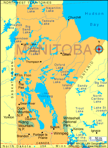
Manitoba is a province located in central Canada, bordered by Saskatchewan, Ontario, Nunavut, and the United States. A map of Manitoba shows a province that stretches from the northern prairies to the Arctic coastline along Hudson Bay. Its central position makes it a key transportation and agricultural region within Canada.
Manitoba is known for its flat landscapes, freshwater lakes, and strong Indigenous heritage. The province includes a mix of urban centers, farming communities, boreal forests, and remote northern settlements.
History of Manitoba
For thousands of years, Manitoba has been home to Indigenous peoples including the Cree, Ojibwe, Dakota, Dene, and Métis. The Red River Settlement became a focal point in the 19th century, leading to the Red River Resistance led by Louis Riel.
Manitoba joined Canada in 1870 as the fifth province. Early growth was driven by agriculture and railway expansion. Over time, the province developed a diverse economy while maintaining strong ties to its Indigenous and Métis roots.
Geography of Manitoba
Manitoba covers approximately 647,797 square kilometers and features a wide range of landscapes:
-
Prairie Plains: Fertile farmland in the south
-
Canadian Shield: Rocky terrain and forests in the east and north
-
Hudson Bay Lowlands: Wetlands and tundra in the far north
-
Freshwater Lakes: Including Lake Winnipeg, Lake Manitoba, and Lake Winnipegosis
Lake Winnipeg is one of the largest freshwater lakes in the world by surface area and plays a major role in the province’s ecology and economy. Manitoba has a continental climate with cold winters and warm summers.
Major Cities
-
Winnipeg: Capital and largest city, economic and cultural center
-
Brandon: Major city in southwestern Manitoba
-
Steinbach: Fast-growing city in the southeast
-
Thompson: Northern regional hub
-
Portage la Prairie: Agricultural and transportation center
-
Selkirk: City near the Red River north of Winnipeg
Facts & Figures About Manitoba
-
Area: 647,797 square kilometers
-
Population: Around 1.4 million
-
Capital: Winnipeg
-
Official Language: English
-
Time Zones: Central Time and Eastern Time in parts of the east
-
Major Rivers: Red River, Assiniboine River, Nelson River
-
Main Industries: Agriculture, manufacturing, hydroelectric power, mining
-
Climate: Continental with cold winters and warm summers
-
Year Established: 1870
People also ask
Where is Manitoba located?
Manitoba is located in central Canada, bordered by Saskatchewan to the west, Ontario to the east, Nunavut to the north, and the United States to the south.
What is Manitoba known for?
Manitoba is known for its prairie farmland, freshwater lakes, polar bears in the north, and strong Indigenous and Métis culture.
What is the capital of Manitoba?
The capital of Manitoba is Winnipeg.
Does Manitoba have access to the ocean?
Yes. Manitoba has a coastline along Hudson Bay in the north, providing access to Arctic waters.
|
|
 |


