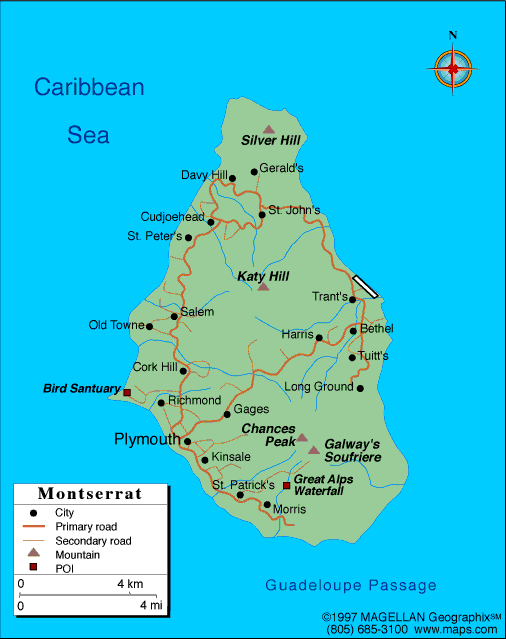
Montserrat Profile
Montserrat is a small island located in the eastern Caribbean Sea, part of the Lesser Antilles island chain. A map of Montserrat shows a rugged volcanic island with steep hills, forested areas, and a coastline shaped by lava flows and erosion. The island is a British Overseas Territory and is often called the Emerald Isle of the Caribbean due to its lush landscape and Irish heritage.
Despite its size, Montserrat is known worldwide for its active volcano and dramatic natural history. Much of the southern part of the island is uninhabitable, while communities and development are concentrated in the north.
History of Montserrat
Montserrat was inhabited by Indigenous peoples before being colonized by the British in 1632. Irish settlers played a significant role in the island’s early population, influencing its culture and traditions. For centuries, the economy relied on agriculture, particularly sugar and cotton.
In 1995, the Soufrière Hills volcano erupted after centuries of dormancy. The eruption destroyed the capital city of Plymouth and forced much of the population to evacuate. Since then, Montserrat has rebuilt its infrastructure in the northern part of the island and continues to adapt to life alongside an active volcano.
Geography of Montserrat
Montserrat covers approximately 102 square kilometers and is entirely volcanic in origin. The island is divided into three main regions:
-
Northern Montserrat: Safest area and center of population
-
Central Montserrat: Forested hills and restricted zones
-
Southern Montserrat: Volcanic exclusion zone affected by eruptions
The Soufrière Hills volcano dominates the southern region and continues to shape the island’s landscape. Montserrat has a tropical climate, with warm temperatures year-round and a rainy season from July to November.
Major Settlements
Montserrat does not have large cities. Key settlements include:
-
Brades: De facto capital and government center
-
Little Bay: Developing port and commercial area
-
Salem: Residential town in the northwest
-
Woodlands: Growing community near new infrastructure
-
Plymouth: Former capital, now abandoned and buried by volcanic ash
Facts & Figures About Montserrat
-
Area: 102 square kilometers
-
Population: Around 5,000
-
Status: British Overseas Territory
-
Capital: Plymouth (de jure), Brades (de facto)
-
Official Language: English
-
Currency: Eastern Caribbean dollar (XCD)
-
Volcano: Soufrière Hills
-
Climate: Tropical maritime
-
Main Industries: Tourism, construction, government services
People also ask
Where is Montserrat located?
Montserrat is located in the eastern Caribbean Sea, south of Antigua and part of the Lesser Antilles.
Why is Montserrat famous?
Montserrat is famous for the Soufrière Hills volcano, which destroyed its former capital and reshaped the island.
Is Montserrat safe to visit?
Yes. The northern part of the island is safe for visitors. The southern exclusion zone remains restricted due to volcanic activity.
Who governs Montserrat?
Montserrat is a British Overseas Territory with local self-government and a governor representing the United Kingdom.
|
|
 |


