Dominican Republic Profile
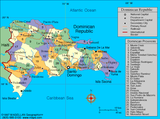
The Dominican Republic is located in the Caribbean, occupying the eastern two thirds of the island of Hispaniola, which it shares with Haiti. A map of the Dominican Republic shows a country defined by mountain ranges, fertile valleys, tropical coastlines, and offshore islands. It is one of the largest countries in the Caribbean by both area and population.
The country is known for its beaches, music, and strong cultural identity shaped by Indigenous Taíno, African, and European influences. Santo Domingo, the capital, is the oldest continuously inhabited European founded city in the Americas.
History of the Dominican Republic
The island of Hispaniola was originally inhabited by the Taíno people before Christopher Columbus arrived in 1492. Santo Domingo was founded in 1496 and became the first center of Spanish colonial rule in the Americas. Over the centuries, the territory experienced Spanish, French, and Haitian control.
The Dominican Republic gained independence in 1844. Its modern history includes periods of political instability, dictatorship, and reform, most notably under Rafael Trujillo in the 20th century. Today, the country is a democratic republic with a growing economy and a strong presence in regional trade and tourism.
Geography of the Dominican Republic
The Dominican Republic covers approximately 48,671 square kilometers and has one of the most diverse landscapes in the Caribbean.
Key geographic features include:
-
Mountain Ranges: The Cordillera Central includes Pico Duarte, the highest point in the Caribbean
-
Cibao Valley: Fertile agricultural region in the north
-
Coastal Plains: Sandy beaches and resort areas along the Atlantic and Caribbean coasts
-
Lakes: Lake Enriquillo, the lowest point in the Caribbean
-
Rivers: Yaque del Norte and Yuna Rivers
The climate is tropical, with warm temperatures year round and a rainy season that varies by region.
Major Cities
-
Santo Domingo – Capital and largest city, political and cultural center
-
Santiago de los Caballeros – Major economic and cultural city in the north
-
La Romana – Industrial city and tourism hub
-
San Pedro de Macorís – Port city with strong baseball culture
-
Puerto Plata – Coastal city known for tourism and beaches
-
Punta Cana – Major resort area and international travel gateway
Facts & Figures About the Dominican Republic
-
Area: 48,671 square kilometers
-
Population: Around 11 million
-
Capital: Santo Domingo
-
Official Language: Spanish
-
Currency: Dominican peso (DOP)
-
Independence: 1844
-
Highest Point: Pico Duarte
-
Main Industries: Tourism, manufacturing, agriculture, mining
-
Climate: Tropical
People also ask
Where is the Dominican Republic located?
The Dominican Republic is located in the Caribbean on the island of Hispaniola, east of Haiti, between the Atlantic Ocean and the Caribbean Sea.
What is the Dominican Republic known for?
It is known for its beaches, merengue and bachata music, baseball, historic cities, and tourism industry.
What language is spoken in the Dominican Republic?
Spanish is the official language and is spoken throughout the country.
Is the Dominican Republic safe to visit?
The Dominican Republic is generally safe for tourists, especially in resort areas. Standard travel precautions are recommended.
|
|
 |


