British Virgin Islands Profile
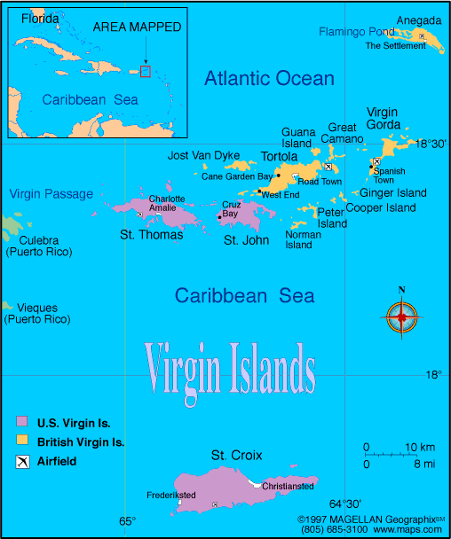
The British Virgin Islands are a group of islands located in the northeastern Caribbean Sea, east of Puerto Rico and north of the U.S. Virgin Islands. A map of the British Virgin Islands shows more than 60 islands and cays scattered across turquoise waters, with mountainous terrain and sheltered bays. The territory is a British Overseas Territory and part of the Virgin Islands archipelago.
The islands are known for sailing, beaches, and marine tourism. Road Town, located on Tortola, is the capital and main administrative center.
History of the British Virgin Islands
The islands were originally inhabited by Arawak and later Carib peoples before European contact. Christopher Columbus sighted the islands in 1493, and they later came under British control in the 17th century.
Plantation agriculture dominated the early economy, relying heavily on enslaved labor until emancipation in the 19th century. In the modern era, the British Virgin Islands developed a strong financial services sector alongside tourism. Today, the territory operates with local self government while remaining under British sovereignty.
Geography of the British Virgin Islands
The British Virgin Islands cover approximately 151 square kilometers of land area and are mostly volcanic in origin.
Key geographic features include:
-
Mountainous Islands: Steep hills and ridges, especially on Tortola
-
Coral Reefs: Surround many of the islands and support marine life
-
Sheltered Bays: Natural harbors used for sailing and anchorage
-
Small Cays: Numerous uninhabited islands and rock outcrops
The climate is tropical, with warm temperatures year round and a hurricane season from June to November.
Major Islands and Settlements
-
Tortola: Largest island and home to Road Town
-
Virgin Gorda: Known for The Baths rock formations
-
Anegada: Flat coral island with salt ponds
-
Jost Van Dyke: Popular destination for sailing and tourism
-
Road Town: Capital and main port
Facts & Figures About the British Virgin Islands
-
Area: Approximately 151 square kilometers
-
Population: Around 30,000
-
Capital: Road Town
-
Status: British Overseas Territory
-
Official Language: English
-
Currency: United States dollar (USD)
-
Climate: Tropical
-
Main Industries: Tourism, financial services, marine services
People also ask
Where are the British Virgin Islands located?
They are located in the northeastern Caribbean Sea, east of Puerto Rico and north of the U.S. Virgin Islands.
What are the British Virgin Islands known for?
The islands are known for sailing, beaches, coral reefs, and offshore financial services.
Are the British Virgin Islands independent?
No. They are a British Overseas Territory with local self government and the United Kingdom responsible for defense and foreign affairs.
Is it safe to visit the British Virgin Islands?
Yes. The British Virgin Islands are generally safe for visitors and have a well developed tourism infrastructure.
|
|
 |


