Barbados Profile
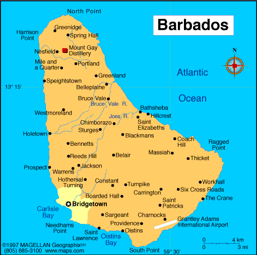
Barbados is an island nation located in the eastern Caribbean Sea and the western Atlantic Ocean. A map of Barbados shows a relatively small, flat island positioned east of the Lesser Antilles island chain. Its location sets it apart from many volcanic Caribbean islands, giving Barbados a unique geological and cultural identity.
The island is known for its coral limestone terrain, strong British heritage, and well developed infrastructure. Bridgetown, the capital, is the main port and commercial center and is recognized as a UNESCO World Heritage Site.
History of Barbados
Barbados was originally inhabited by Indigenous peoples before being claimed by England in 1625. It became one of Britain’s oldest and most stable colonies in the Caribbean, with an economy historically centered on sugar plantations worked by enslaved Africans.
Barbados gained independence from the United Kingdom in 1966 and later became a republic in 2021, with a locally elected head of state. Since independence, the country has developed a strong tourism and services based economy while maintaining political stability.
Geography of Barbados
Barbados covers approximately 430 square kilometers and is primarily composed of coral limestone rather than volcanic rock.
Key geographic features include:
-
Central Highlands: Rolling hills rising toward Mount Hillaby
-
Eastern Coast: Rugged cliffs facing the Atlantic Ocean
-
Western Coast: Calm beaches along the Caribbean Sea
-
Coral Limestone Terraces: Shape much of the island’s landscape
-
Underground Caves: Extensive limestone cave systems
The climate is tropical, with warm temperatures year round and a wet season from June to November.
Major Cities and Towns
-
Bridgetown: Capital and largest city
-
Speightstown: Historic town in northern Barbados
-
Oistins: Fishing town and cultural center
-
Holetown: One of the oldest settlements on the island
-
Bathsheba: Coastal village on the Atlantic side
Facts & Figures About Barbados
-
Area: 430 square kilometers
-
Population: Around 280,000
-
Capital: Bridgetown
-
Official Language: English
-
Currency: Barbadian dollar (BBD)
-
Independence: 1966 from the United Kingdom
-
Government Type: Republic
-
Climate: Tropical
-
Main Industries: Tourism, financial services, manufacturing
People also ask
Where is Barbados located?
Barbados is located in the eastern Caribbean, east of the main Lesser Antilles island chain and bordering the Atlantic Ocean.
What is Barbados known for?
Barbados is known for its beaches, coral reefs, rum production, and strong cultural traditions.
Is Barbados volcanic?
No. Barbados is primarily made of coral limestone, unlike many volcanic Caribbean islands.
Is Barbados safe to visit?
Yes. Barbados is generally considered safe for visitors and has a well established tourism infrastructure.
|
|
 |


